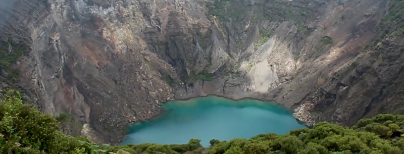
Irazu National Park is an area that interests students and scientists for its geology, its neighbors who depend on it or, its water resources, and as a tourist attraction. The origin of the name Irazú comes from an Indian village on the volcano slopes that was called “Iztarú”, meaning: “thunder quake mountain”. Over the years this was modified to Irazú. The mountain is also known by the name ‘Santa Bárbara Mortal de la Naturaleza.
Irazu National Park makes part of the Central Volcanic Mountain Range Conservation Area. It is located in the Canton of Oreamuno, 32 Km. northwest of Cartago. It was declared a Costa Rica national park in June 1955 as part of the original law that established the Costa Rican Tourism Board.
Geology
The Irazu volcano massif is classified technically as a stratovolcano, which means that it is made up of different layers of volcanic material and that it has an irregular semi-conical shape. It is made up of five craters: the Main crater, the Diego de la Haya crater, Playa Hermosa crater, Laguna crater, and Pyroclastic crater. Irazu volcano is an active volcano sending fumaroles that erupt and produce pyroclastic flows and ash, accompanied by relatively light tremors.
History of Irazu volcano
The Irazu volcano has had repeated eruptions over the years. The first documented eruption was in 1723, recorded by Diego de la Haya Fernández, the governor of Cartago at the time. From 1963 to 1965, the Irazu volcano began a period of intense activity, which devastated the surroundings of the crater and seriously affected San Jose and Cartago with volcanic ash fall. In 1963, an accumulation of volcanic material in the canal of the Reventazon River sent it over its banks and caused flooding in the community of Taras, Cartago, destroying more than 300 houses. In 1994 a sudden explosion on the northern wall of the Main Crater produced a landslide that reached the Sucio River, and made its way under the Braulio Carrillo Highway bridge.
Flora and fauna
Due to the altitude, past agricultural practices, and volcanic activity, wildlife is not abundant on the area. Most of the forest in Irazu national park is found on the Caribbean side of the volcano. Around the craters, one can observe a low scrub, dominated by species like the calico tree, poor man umbrella and Bursera arborea, which has colorful yellow flowers.
The majority of these high-elevation plants have specialized characteristics in the size and thickness of their leaves, which are generally small, thick, and hard. These adaptations allow them to tolerate strong winds and sudden changes of temperature. Some plants also have reddish substances in their leaves and branches that help them protect themselves from the effects of intense solar radiation.
In other parts of the Irazu national park trees such as oaks and Elaeagia uxpanapensis can be seen often covered by epiphytes. Some of these are parasitic like the tree killer, which has orange inflorescence that can be seen from a great distance.
Larger animals are scarce, though there are coyotes, Brazilian rabbit, red-tailed squirrel, and Mexican Hairy Porcupine. Birds are more numerous, and the more common species around the craters include the Volcano Junco and Acorn Woodpecker, while Clay-colored Thrush and Black-faced Solitaire inhabit the forests.
Interest facts
- Irazu Volcano National Park has an area of 2.000, 37 ha.
- The temperature varies from 3ºC to 17ºC. The rainy season is from April to December, with an average precipitation of 2.158 mm.
- Irazu is the highest volcano in Costa Rica, with an elevation of 3.432 meters.
- You may observe three of the craters, including the Main crater, which is 1,050 meters in diameter and 300 meters deep, and has a sulfurous green lake at the bottom.
- The Diego de la Haya crater is 690 meters in diameter and 80 meters deep.
- The Playa Hermosa crater is a large ashy beach that at one time was an active crater. Its plant life is gradually regenerating making it a good place to observe the bird life of the park.
